Phu Yen is a province on the South Central Coast, a land with a rich history and culture, with a very important position in the development process of the Vietnamese people. With much development potential, Phu Yen is gradually becoming a bright investment center, especially in the real estate sector. Therefore, the province’s planning information is always interesting and updated by investors.
Details of Phu Yen province’s regional planning are specifically stated in Decision No. 502/QD-TTg dated April 10, 2020 of the Prime Minister approving the task of planning Phu Yen province for the period 2021 – 2030, vision by 2050.
Through this article, Sen Vang Group will summarize some highlights so that readers can quickly and accurately grasp information about Phu Yen province’s regional planning to 2030 and vision to 2050.

Tuy Hoa city, Phu Yen province (Source: compiled by Sen Vang)
Planning goals
Phu Yen province planning for the period 2021 – 2030, vision to 2050 to build development scenarios, ideas and overall plans; Reasonably arrange space to resolve space conflict issues in the province today and space orientation for future development needs. Ensure synchronous connection between national planning, national sector planning, planning of the South Central region and planning of Phu Yen province. The goal of building Phu Yen province to sustainably develop all three pillars: economy – society – environment and ensuring harmony of 5 factors “economy – social security – environment – national defense and security” – cultural values.
Research scope
The scope of the study is the entire administrative boundary of Phu Yen province, total natural area is 5,023.4 km2, with 9 district-level administrative units including: Tuy Hoa City, Song Cau Town, Dong Hoa Town and Districts: Dong Xuan, Song Hinh, Son Hoa, Phu Hoa, Tay Hoa, Tuy An.
Highlights in Phu Yen province’s regional planning to 2030 and vision to 2050
1. Orientation for spatial development
Spatial development orientation of Phu Yen province includes 3 regions: coastal and coastal areas, delta areas, and mountainous areas. Specifically:
– Sea and coastal areas: Build sea and coastal areas with high, stable and sustainable economic growth; is a multi-sectoral, multi-functional economic area with an advanced level of development; Focus on building the South Phu Yen Economic Zone into a breakthrough development area, industrial trade center, and seaport of the South Central Coast and Central Highlands. Complete coastal roads and roads connecting National Highway 1A to coastal beaches; Research solutions to prevent climate change and rising sea levels to limit natural disasters.
– Delta region: A region for rural and handicraft development, forming small and medium-sized processing industry establishments with many levels of technology, developing craft villages, diversifying products and services. , making satellites for large enterprises, creating local jobs for workers; Focus on developing irrigation systems, promoting research on plant varieties and animals, applying scientific advances in production, forming concentrated production areas to provide raw materials for processing and investment industries. Transport routes linking the region.
– Mountainous regions: Maximize internal resources, take advantage of investment support from outside to bring the region’s economy to develop quickly and sustainably, gradually escape the state of underdevelopment, improve material and economic life. spirit of ethnic minorities, maintaining national defense – security and protecting the ecological environment; Complete the western transport axis of the province, DT648, forming horizontal transport routes linking the region, supporting the development of mountainous rural areas; Focus on investing in health care, education, irrigation, clean water supply, sedentary farming and population stabilization.

Spatial organization chart of Phu Yen province to 2030, vision to 2050 (Source: compiled by Sen Vang)
2. Land use planning
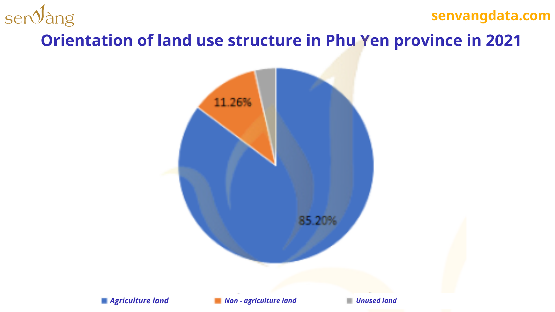
By 2021, most of Phu Yen province’s land will be agricultural land, accounting for more than 85% of the province’s land area. Among agricultural land, agricultural production land, forestry land and production forest land are the three types of land with the largest area. The area of non-agricultural land is low at 11.26%, mainly specialized land. Unused land accounts for 3.54%, mainly unused hill land.

Land use structure chart of Phu Yen province in 2021 (Source: Compiled by Sen Vang)

Map of land use planning until 2025 in Phu Yen province (Source: Compiled by Sen Vang)
In 2021, agricultural land accounts for the majority of the province’s land use structure, showing that non-agricultural production has not yet developed strongly. However, according to the spatial development orientation of Phu Yen province, we see that the province has learned to focus on development in accordance with its inherent potential, especially developing marine and coastal economic zones, promoting the formation of coastal areas. marine processing industrial establishments, diversifying products and services for tourism.
3. Transportation infrastructure
3.1 Road
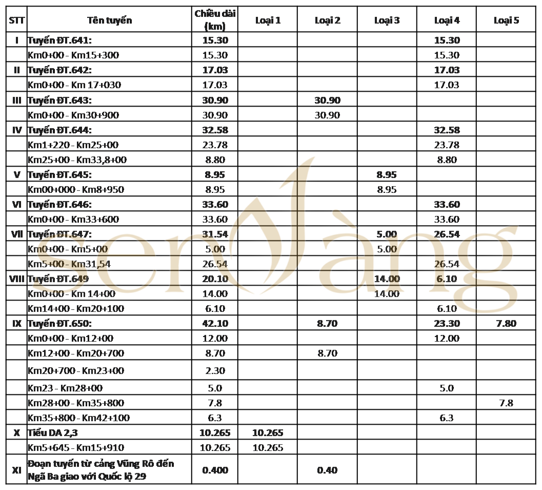
Phu Yen province has a diverse road transport network that can meet many people’s needs and meet the development of many industries, with many arterial roads connecting the network between Phu Yen. with neighboring provinces and cities, creating a driving force to boost the economy of the province and region.
A number of important roads are focused on development and investment by the province such as: National Highway 1A, National Highway 1D, National Highway 19C, National Highway 25, National Highway 29,… along with provincial and district roads that are being built. Expand and upgrade every day.

Provincial road traffic system of Phu Yen (Source: compiled by Sen Vang)
As of 2020, the province has 27 bus stations, 4 parking lots, 1 bus stop and 24 passenger pick-up and drop-off stops. Seeing that the development of road traffic has not only improved people’s lives, making it easier for people to travel, but also contributed to promoting the economic and social development of the entire province, expanding possibilities. trade and travel between provinces and regions.
3.2 Railways and airways
The total railway length of Phu Yen province is more than 49 km, passing through Tuy An, Phu Hoa, Tay Hoa districts, Tuy Hoa city and Dong Hoa town. Contributing greatly to the development of goods trade and transportation within the province as well as between Phu Yen province and other provinces. However, many road sections are still damaged and degraded, requiring restoration and continued expansion to meet greater needs for future development.

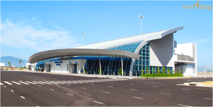
Tuy Hoa Airport in Phu Yen province (Source: compiled by Sen Vang)
Besides railways and roads, airways are also a key investment focus of Phu Yen province. With the appearance of Tuy Hoa airport, it has become a boost, leading to the outstanding development of many aspects of the entire province such as tourism, transportation,… becoming the face of Phu Yen. Helps travel from remote provinces become more convenient than ever, in addition to gradually improving transport infrastructure, improving traffic connectivity between regions, contributing to local economic, social and security and defense development.
3.3 Waterways
The marine economy, sea and coastal areas have been becoming the driving force for development of the country, especially for Phu Yen – a place with unlimited potential to develop the marine economy.

Vung Ro seaport in Phu Yen province (Source: compiled by Sen Vang)
Phu Yen is a South Central coastal province, with a coastline of 189 km, with large fishing grounds and rich aquatic resources; Many lagoons and bays are sheltered from the wind, convenient for farming, aquaculture, and developing tourism services and seaports. Therefore, it could not be more favorable for the province to develop its marine economy such as: marine tourism, fishing ports, deep-water seaports, warehouses,… welcoming many ships and boats from different localities, creating a great driving force for development of the province’s economy.
4. Key project
4.1 North-South Expressway Project through Phu Yen
The North – South Expressway Project is a project with a total length of about 90 km, running parallel and about 0.5 – 6.5km from National Highway 1, with two component projects: Quy Nhon – Chi Thanh and Chi Thanh sections. Thanh – Van Phong.

North – South Expressway Project in Phu Yen (Source: compiled by Sen Vang)
The project passes through 6 districts, towns and cities: Song Cau, Tuy An, Tuy Hoa, Phu Hoa, Tay Hoa and Dong Hoa. With a roadbed design of 17 m, with 4 lanes. At the completion stage, the project has a roadbed design of 32.25 m, with 6 lanes, and a design speed of 120 km/h. This is a key project with an investment capital of more than 19,000 billion VND, and is an important arterial road in connecting and trading Phu Yen with other localities.
4.2 Hoa Tam Industrial Park
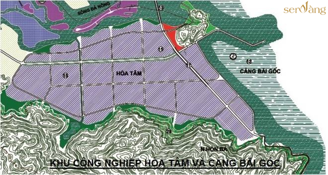
This is an industrial park project with an area of 1,080 hectares, associated with the formation and development of Bai Goc Port, located on Highway 29 in Hoa Tam commune, Dong Hoa town, Phu Yen province. 24 km from Tuy Hoa city center, 15 km from Vung Ro Port, 17 km from Tuy Hoa Airport.

Hoa Tam Industrial Park in Phu Yen (Source: compiled by Sen Vang)
With the appearance of Hoa Tam industrial park, it has had a very positive impact on the socio-economic development of Phu Yen province. Contributing to strongly attracting foreign investment, stimulating supporting industries to develop, creating jobs for thousands of people,… The project has become an important lever in promoting the economy. economy and society of Phu Yen province as well as the country in general.
|
Above is general information about “Regional planning of Phu Yen Province to 2030 and vision to 2050” Provided by Sen Vang Group. Hopefully the above information will help developers, investors and real estate businesses have an overview of investment efficiency and the policy of linking black areas back to the. In addition, to see more articles about the Mekong Delta region, readers can visit the website senvangdata.com. |
|
Compiled source: Sen Vang Group – Editor Pham Dac Trieu
Contact Info:
Website: https://senvangacademy.com/
Hotline: 0948.48.48.59


Copyright © 2022 Copyright belongs to SEN VANG GROUP